Multi-Disciplinary Solutions for Stormwater Flooding
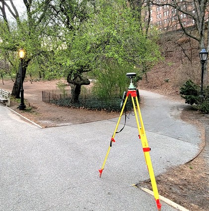
Due to a myriad of reasons ranging from aging infrastructure to insufficient upland drainage protection, Riverside Park experiences severe flooding events during major storms. This has created areas of significant erosion to site landscaping and features, upland pathways, and potentially to retaining walls. The stormwater runoff is frequently impounded in large areas, creating unwanted detention basins and surface ponding across walkways and grass areas. Matrix performed topographical surveying and geotechnical engineering services to provide a pre-scoping level of surveying and subsurface investigation at the park. Our survey team gathered record information from multiple sources and created a comprehensive GIS database for the entire 270-acre park. We utilized this database to locate and investigate over 1,000 stormwater and combined system structures within Riverside Park, Riverside Drive, and the Henry Hudson Parkway. Each structure was photographed, sketched, and invert elevations were recorded with pipe size, type, and direction. All field data was added to the GIS database. Matrix also procured aerial mapping for the entire project, which was updated by our field crews to fill in voids due to shadows and vegetation, and surveyed over 1,100 trees after they were tagged for inventory by arborists.
In addition, we performed geotechnical engineering to investigate subsurface conditions and evaluate their impact on the proposed construction and arranged for the drilling subcontractor to complete the subsurface exploration program. Our program consisted of 22 geotechnical soil borings coupled with 22 permeability borings to assess the site’s ability to effectively infiltrate stormwater and provide a geotechnical baseline for the drainage design of proposed improvements. Matrix also conducted nutrient testing on select samples to determine the topsoil’s viability in supporting adequate natural vegetation to aid in stormwater control.
Services Provided:
- Geotechnical Engineering
- Survey
- GIS Services